Private Transport Demand Assessment
Modern methods (computer algorithms) used to assess private transport demand try to find all possible routes (paths) to go from point A to point B. And this is done for all possible places in an area. Thus, if an area has ten locations, it will have 100 possible journeys. And the computer will try to find out all possible routes for each of those 100 possible journeys. It will then distribute the travel demand between competing routes based on their relative distance, time or cost involved. Methods to do these tasks are highly efficient and take into consideration the effect of congestion as well. A road is used less when the demand on it makes it more congested and time consuming. But the methods are still not very good at mixing various different systems. For example, if we need to assess travel demand for people who use a car to go to a parking lot and then ride their bicycle for some distance to their workplace (which they have been carrying on top of their car), the methods are not very efficient. Fortunately, such travel phenomenon is rare (although not completely absent) and that is why, it does not matter much.
Public Transport Demand Assessment
Methods used to assess public transport demand also work in a similar manner. All possible routes are found to go from point A to point B. And this is done for each pair of locations (100 pairs if we continue with the example introduced above). The method of distributing the demand among competing routes is also very similar and one can choose to do this based on either distance, time or cost involved. Unfortunately, methods to assess public transport demand are NOT very good in considering congestion. This is mostly because the methods were developed in western countries where congestion on public transport is unheard of. While it is extremely important for a country like India where crowding in buses and trains is more of a rule rather than an exception, we have not developed reliable methods to take this into account while forecasting demand for public transport.
[Private + Public] Transport Demand Assessment: Park & Ride
With a summary discussion of the private and public transport demand above, we are now ready to look closely into what makes it so difficult when these two types of modes are mixed. Do take a look at the diagram provided below. There are two additional problems when trying to find the path from point A to point B from a ‘Park & Ride’ perspective.
1. The paths will be composed of two legs
a. The first leg from point A to the station where the person boards the train
b. The second leg from the station where the person hops on to the station where s/he hops off
2. Not only will there be many routes to choose from while going from point A to the station but the station itself will be subjected to a choice. A traveller can always choose an alternative nearby station and still perform the journey from A to B. (Imagine someone living in Juhu, Mumbai and travelling to the city: the choice s/he has to make between Andheri and Vile Parle. Or someone living in Safdarjang Development Area, New Delhi and trying to choose between Green Park and Hauz Khas Metro stations).
The second issue highlighted above makes the problem difficult to understand and sometimes, intractable. This is especially true in case of big metropolitan cities such as Delhi (with its Metro stations) and Mumbai (with its WR and CR suburban rail stations) and when one has to find out the Park & Ride potential of all stations.
And for this reason, assessment of Park & Ride demand in most transportation studies is ignored. Even if it is taken up, approximations are sought. We discuss below some of the approximations devised to circumvent the problem of station choice highlighted above.
Storing Travel Demand – A special case of Park & Ride
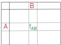
 Travel demand for the purpose of transport planning is usually stored in terms of ‘Trip Tables’. In these two dimensional tables, each row represents a starting location and each column represents a location where the journey ends. This enables each cell of the table to represent a pair of location. Therefore, the cells can be used to store any characteristic of the journey from A to B i.e., total demand, travel time, etc. So we can have a table for total demand from everywhere to everywhere. And another one can be used to store travel time from everywhere to everywhere.

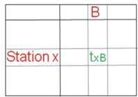
 In the figure below, an abstract table is shown storing the travel time ‘t’ to go from location A to location B.
In case of Park & Ride, the demand has to be broken down into two components as shown below. The first part (a table) stores the demand from location A to the station (X) and the second part (another table) stores the demand from same station to the destination. It has to be kept in mind that the station in the above tables is an unknown (to be chosen). And for this reason, the process of finding the path from A to B has to be repeated for every possible station which can be used between A and B to find out the one with the minimum time (or cost). There are algorithms available now to solve this problem and they fall under the generally category of ‘Matrix Convolution’ or ‘Triple Index Operations’.
Ignore the demand by Park & Ride
This is mostly the status quo. While the demand for Park & Ride has growth potential provided the right kind of facilities is given, the reason cited for not providing it is mostly the absence of the demand. This becomes a classic chicken and egg story and consequently, it is not taken up in any of the transportation studies.
Fix the station to a set of locations
This is done to simplify matters. A set of locations is permanently tied to a public transport interchange or a station. The basic assumption is that all persons located in a particular area do not have a choice and they will choose only one station (the one that is decided by the person investigating the problem).
The right way – Estimating Park & Ride demand as a two leg chained trip
 The right way to understand the nature of demand for Park & Ride mode is not to ignore any of the complexities involved and devise algorithms to work around such complexities. Following are seven major steps involved in doing this:
1. Recognise Park & Ride as a distinct mode in its own right, distinct from public transport accessed by walk.
2. Have all the stations recognised as distinct locations to enable estimation of distance, time and cost to reach them.
3. Clearly distinguish between locations which are Park & Ride sites and all other locations.
4. Calculate the ‘best’ Park & Ride site for each pair of location.
5. Calculate the total cost (including the parking cost) of travelling for each pair of location. This should include the cost of travel by private transport, parking cost and public transport fare.
6. Once the demand is estimated for each location pair, split it into its component parts (private transport part and public transport part).
7. Load the first component (the private transport) on the road network and second component (public transport) on the rail/bus network.
Transportation mess is mostly blamed on lack of funds, technology or policy. It goes unnoticed that many solutions are ignored because of exactly the opposite reason, i.e., they may not need lot of borrowed funds or fancy technology and that is why they get ignored. And if the solutions required involve doing cumbersome planning and design that will need some difficult maths, the idea gets buried before even a case is made. Planning for Park & Ride at a metropolitan scale and incorporating it in our travel demand studies is one such idea. International engineering consultants, when working in the ‘first’ world and subject to stringent study briefs and guidelines, do deliver such solutions.
While mathematically and computationally, such algorithms are available and used in most of the transportation studies internationally, they have not been put to use in any of the transportation studies in India. As mentioned earlier, the main reason cited has been the lack of demand for Park & Ride. On the other hand, it is noted that by its very nature, demand for Park & Ride is not expected to manifest itself unless the right infrastructure is put in place. Assessing the right amount of parking required for such facilities is the key and it is important that the methods required for such assessment are made use of, however complex or intractable they might seem.
It is hoped that future transport studies for metropolitan areas in India make use of the state-of-art solutions discussed above and better inform the downstream projects such as station design and station precinct planning.
(Vikas Sharma has over 16 years total experience in transportation planning, travel demand modelling and GIS development. He has a Bachelors degree in Urban & Regional Planning and a Masters degree in Transportation Planning with extensive experience with Information Management/Sciences. He works extensively in the application of software tools for transport network planning and operations.)
 TrafficInfraTech Magazine Linking People Places & Progress


