
K. Vijaya Lakshmi, Managing Director, HUMTA
Hyderabad Unified Metropolitan Transport Authority (HUMTA) for Hyderabad Metropolitan Region (HMR) was constituted with an objective to ensure the implementation & co-ordination of various Traffic & Transportation measures undertaken by concerned departments and public agencies, in the Region spreading across 7.228 sqkm. The objectives include enhancing seamless travel and improve first and last mile connectivity to public transport. K. Vijaya Lakshmi, Managing Director, HUMTA, shares details about the overall strategies and development plan for Hyderabad.
Hyderabad city has multiple agencies that are responsible for urban transport such as Greater Hyderabad Municipal Corporation (GHMC), Hyderabad Metro Rail Limited (HMRL), Hyderabad Metropolitan Development Authority (HMDA), Hyderabad Road Development Corporation Limited (HRDCL), Hyderabad Growth Corridor Limited (HGCL), Traffic Police, Road Transport Authority (RTA), Telangana State Road Transport Corporation (TSRTC), Roads & Buildings Dept. (R&B), National Highways Authority of India (NHAI), South Central Railways (SCR), GMR Hyderabad International Airport Limited (GHIAL) / Airport Authority of India (AAI) and Government of Telangana (GoT). HUMTA is actively coordinating with all the above mentioned stakeholders for effective planning and implementation of various traffic and transportation infrastructure in HMR.
 Existing Transportation Scenario
HMR is well connected with different parts of the state as well as country by road, rail and air. HMR has robust public transport network which includes city bus services by TSRTC, metro rail services by HMRL and MMTS (local trains) and sub-urban trains by SCR.
The current mode share of city is dominated by private vehicles which accounts to 51% and then followed by public transport (32%). In pre-covid scenario, around 3600 city buses in 776 routes were being operated in the city serving about 36 lakh passengers; Metro rail network of 68 kms is serving the city with the daily
ridership of about 4 lakhs; MMTS is being operated in the nine routes accounting to 46 kms. Apart from these, sub-urban services are being operated in 14 routes connecting the urban fringes of HMR.
Current projects
Comprehensive Transportation Study for HMR
The main objective of the CTS study is to provide a immediate, short, medium and long term strategy for desirable mobility of residents of HMR to cater the growing population and employment and change in land-use. CTS for HMR was originally conducted in the year 2011. Contextual Refinement of the CTS has been undertaken in 2016 to reflect the impact of bifurcation of the state and to incorporate the vision of the new government.
The forecasted population of HMR is 18.1 million and employment is 9.3 million by 2041. In order to cater the expected growth CTS has proposed the following MRTS system by 2041 for the city to enhance the public transport connectivity:
- 204 km of Metro,
- 137 kms of LRTS / Metro Neo / Metrolite and
- 264 kms of MMTS (Local Train)
- 390 kms of Dedicated Bus Corridors
The other major recommendations / developments proposed in CTS are as follows:
- Bus fleet augmentation and rationalisation of bus routes
- Footpath and cycle tracks (450 kms),
- Road corridors which include development of missing road links and improvement of existing roads (40 roads),
- Congestion mitigation measures such as junction improvements (294 junctions), traffic management measures (5 areas),
- Intercity bus terminals (7 terminals),
- Intercity railway terminals (4 terminals) and
- Truck terminals/ Logistic hubs (14 terminals)
For the implementation of these, following strategies for Institutional strengthening, Policies & Implementation Strategies and Resource Mobilisation are also proposed in CTS.
- Creation of Urban Transport Fund (UTF) under HUMTA
- Creation of Traffic and Transportation Unit in GHMC and other Urban Local Bodies (ULBs)
Mass Transit System from Kukatpally Housing Board (KPHB) to Kokapet
Kokapet and Financial District are high potential developable areas in the city both in residential and commercial land-use. The major strengths of these areas are direct connectivity from Hyderabad Outer Ring Road and proximity to the areas such as Gachibowli and Hitech City (IT hubs of Hyderabad).
With an objective to connect the existing metro with the upcoming developments in the city, Light Rail Transit System is proposed from Kukatpally Housing Board to Kokapet via Hitech City and Financial District. The proposed LRTS integrates with existing Red Line of Metro at KPHB, Hitech city MMTS station, existing Blue Line of Metro at Raidurg, proposed phase 2 metro line at Gachibowli – Miyapur Road Junction and to
Hyderabad Airport Express Line at Narsingi. The estimated daily ridership of the corridor is Rs.6.40 lakhs by 2043.
Ropeway & Personalised Rapid Transist System
To improve the accessibility of metro to the congested area of the city, mass transit systems such as Ropeway and Personalised Rapid Transit Systems (PRTS) are being explored in Hyderabad as a feeder service in the following two corridors.
- Corridor-I: Along Musi River (Ropeway): Mahatma Gandhi Bus Station (MGBS) to Zoological Park – 5.5 km
- Corridor-II: East – West Corridor (PRTS): Khairatabad – Assembly – Paradise – 9.0 km
Corridor I and II will act as a feeder service to the existing metro corridors to improve the First and Last mile connectivity.
North-South Mobility Corridor
A feasibility study is undertaken with the grant from Agence Française de Développement (AFD) with objective to connect North and South of city i.e. from Jubilee Bus Station (JBS) to Charminar with suitable public transport system. The system recommended as part of the feasibility study for the corridor is New Generation Tram (NGT). The total length of the corridor is 10.4 kms with 17 stations. This corridor integrates with the metro green line at Jubilee Bus Station. The estimated daily ridership of this corridor is Rs. 3.5 lakhs by 2030.
First and Last Mile Connectivity
HUMTA has initiated a study for the improvement of First and Last Mile Connectivity to Metro. Initially, 10 metro stations are selected on pilot basis. HUMTA in coordination with HMRL and TSRTC has identified gaps and in process of preparing suitable measures for enhancing First and Last Mile connectivity. On completion of the present scope, the Authority is planning to extend the work to all the Metro, MMTS, Suburban, and TSRTC stations / terminals in HMR. As part of this project, physical, network and operational integration of the public transport systems in HMR will be improved.
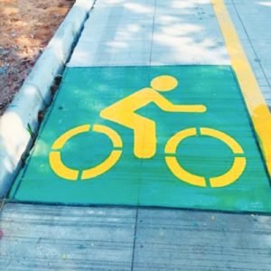
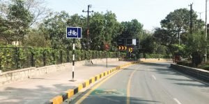
Non-Motorised Transport
HUMTA has initiated the development of infrastructure in the city to promote the use of NMT. The scope of this project includes development of pedestrian and bicycle tracks across the various zones of GHMC i.e. Kukatpally (84 kms), LB Nagar (118 kms), Serlingampally (61 kms) and Secunderabad (77 kms). The scope of the project also includes introduction of Public Bicycle Sharing (PBS) along with docking stations at various locations of the city, provision of required markings and signages to ensure safety of NMT users and implementation of traffic calming measures on various corridors of the city.
As part of Cycle 4 Change challenge, HUMTA and GHMC have developed two pilot corridors with least cost cycle tracks of about 16.5 kms around KBR park and on P.V. Narasimha Rao Marg.
Warangal Metro Neo
Warangal is the second largest city in the state of Telangana with population of about one million. With an objective of developing a mass rapid transit system, Metro Neo system is proposed to be developed connecting Kazipet, Hanamkonda and Warangal. HUMTA is providing technical assistance to Kakatiya Urban Development Authority (KUDA) in preparation of DPR. The length of the project corridor is 15.5 km with 21 stations and the alignment includes 8.4 kms at-grade system and 7.1 kms elevated system. Metro
Neo integrates with Kazipet Railway Station, Hanamkonda Bus Stand, Warangal Railway Station and Warangal Bus Stand. The estimated daily ridership is about Rs.3.12 lakhs by 2051.
Ropeway from Raigir to Yadagirigutta
Yadagirigutta is a famous temple town at a distance of around 65 kms from Hyderabad city. A shrine of Lord Laxmi Narasimha Swamy on the hillock is a famous attraction of Yadagirigutta. In order to improve the access to the temple and surrounding areas, HUMTA is currently conducting a feasibility study to connect Raigir (NH-163) to Yadagirigutta temple by ropeway. The proposed integrated transport and tourism system to Yadadri Railway Station to provide easy access to commuters from Hyderabad.
Common Mobility Card
HUMTA is coordinating with Information Technology, Electronics & Communication (IT&CE) Dept. to provide Common Mobility Card by name One Telangana Card (OTC). OTC is a prepaid and contactless smart card and is intended to enable seamless travel among various modes such as Hyderabad Metro Rail, TSRTC Buses, MMTS, Auto Rickshaws, Cabs and also non-transit applications. OTC will reduce the waiting time of the passengers, enhance the seamless transfers between the modes and promote the digital payments.
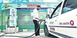
E-mobility
E-vehicles Charging Infrastructure plays a key role in faster adaptation of e-mobility. Government of Telangana has notified E Vehicles & Energy Storage Systems policy in 2020 to promote e-mobility.
HUMTA in coordination with Telangana State Renewable Energy Development Corporation and other stakeholders has identified 118 locations across the city for installation of electric vehicle charging stations across the city. Further, HUMTA is coordinating with HMRL, TSRTC and SCR for installation of EVCI at respective passenger stations / terminals.
HUMTA has also taken up the amendments to legal frameworks for facilitating or preparing guidelines for EV ready building on both ends of trip.
Installation of CCTV Cameras
The safety and security of the citizens is of paramount importance to the Government of Telangana and the state has been taking various steps to ensure the public safety and security in the city of Hyderabad. In this context, and among several measures, network of CCTV surveillance cameras are being installed at strategic locations for the public safety and security.
HUMTA is coordinating with Traffic Police, GHMC, HMRL, SCR, TSRTC, TSIIC, HGCL etc for effective implementation of installation of CCTV cameras for the safety of commuters in the urban transport systems.
In addition to the project formulation and coordination, HUMTA is working on development of various policies like Sustainable State Urban Transport Policy; Gender Policy related to Transportation; Transit Oriented Development (TOD) Policya and Non-Motorised Transport Policy. Tne guidelines being developed are for Traffic Impact Assessment Guidelines and Standardisation of signages and cross-sections.


